mercoledì 8 novembre 2017
Cockney London Pub: Al Jolson - Il cantante di Jazz
Cockney London Pub: Al Jolson - Il cantante di Jazz: " You ,jazz singer ! " Se qualcuno avesse il dubbio, è un insulto pesante . Siamo nel ghetto di Manhattan Lower, nella ...
lunedì 27 marzo 2017
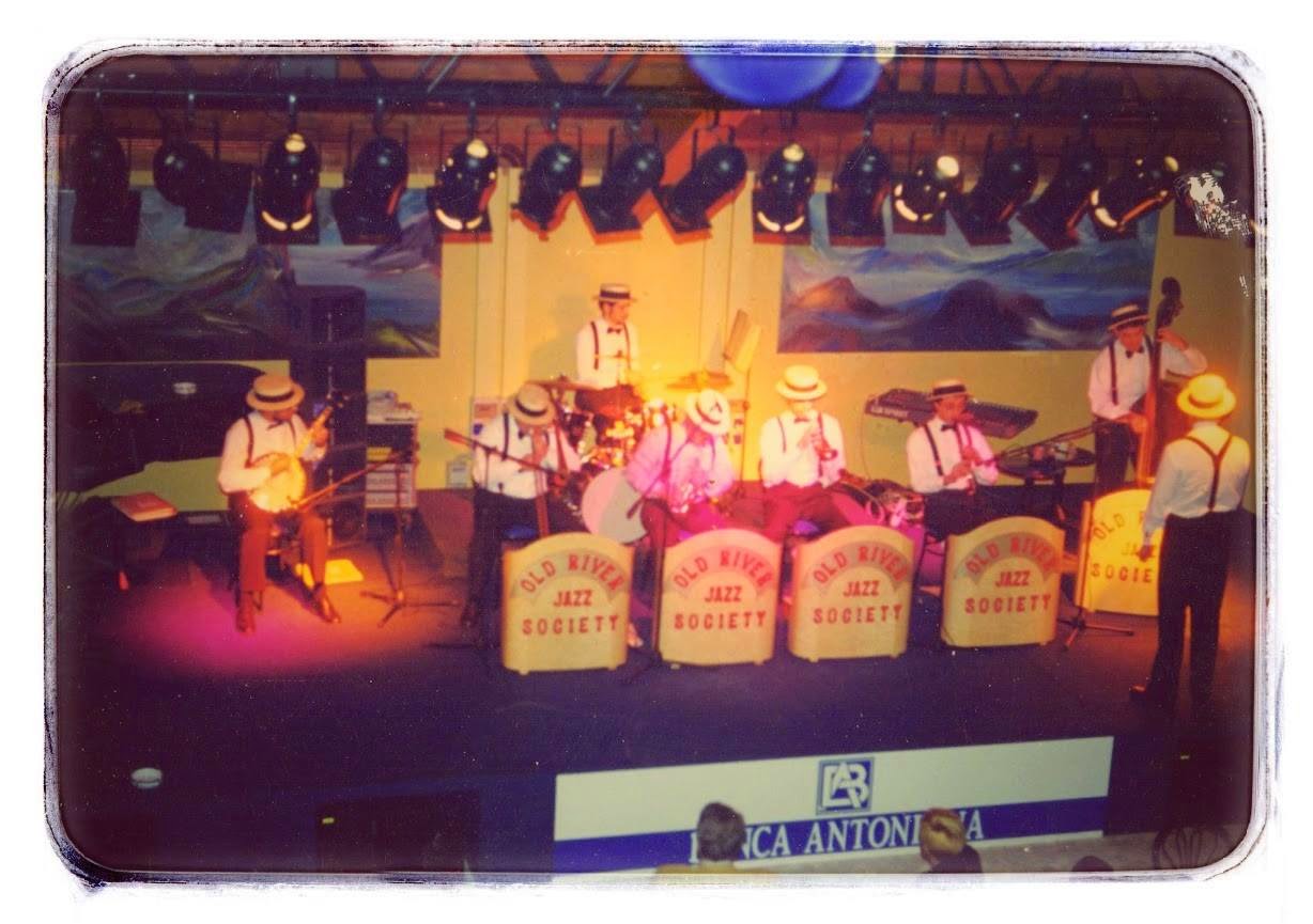
Teatro Tenda Parco Magnolia Abano Terme That's a plenty
****
THAT'S A PLENTY
mercoledì,8 giugno 1994
*****
mercoledì,8 giugno 1994
*****
Brano tratto dal concerto jazz tenutosi al teatro-tenda
del Parco Magnolia di Abano Terme
del Parco Magnolia di Abano Terme
Oltre alla consueta formazione della Old River Jazz Society,partecipò come
Guest Star Zeno Odorizzi, sax soprano della Doctor Dixie Jazz Band di Bologna
FABIO BETTELLE-tromba
MORENO MILANETTO-trombone
FEDERICO RANZATO-clarinetto
MARCELLO MASSELLANI-sax baritono
****
RENZO RIZZARDO-piano
GIANNI ZAMBORLIN-basso tuba
RICCARDO RANZATO-banjo
LUCIANO TRISTO-batteria
*****
ZENO ODORIZZI-sax soprano
ALBERTO MARIA CIPOLLI-direttore,arrangiatore e Jazz crooner
giovedì 12 febbraio 2015
Storia della Old River Jazz Society
Hotel Terme Tritone -Abano Terme
debutto della prima OLD RIVER JAZZ SOCIETY
Dicembre 1991
Dicembre 1991
Front line
Luigi Roveran -tromba
Claudio Pacchiani-clarinetto
Marcello Massellani-sax baritono
Second line
Renzo Rizzardo-piano
Moreno Milanetto -sousaphone
Luciano Tristo-batteria
Arrangiatore e conduttore-Alberto Maria Cipolli

Hotel PARK
Abano Terme
Dicembre 1991

**********************
TEATRO CONCORDIA
San Benedetto Del Tronto
venerdi,5 settembre ( prove)
sabato,6 settembre ( prove)
domenica ,7 settembre 1992
Spettacolo teatrale organizzato dal
sindacato pensionati CISL

Associazione Culturale GATTAMELATA ( Padova )
Concerto Jazz alla Basilica del Santo
29 settembre 1992

debutto della seconda OLD RIVER JAZZ SOCIETY
debutto della seconda OLD RIVER JAZZ SOCIETY
Fabio Bettelle-cornetta
Federico Ranzato-clarinetto
Moreno Milanetto-trombone
Marcello Massellani-sax baritono
***
Renzo Rizzardo-piano
Riccardo Ranzato-banjo
Gianni Zamborlin-basso tuba
Luciano Tristo-batteria
***Arrangiatore/conduttore : Alberto Maria Cipolli

Provavamo
ogni martedì sera in una stanzetta con il pavimento in legno al primo piano di un
rustico disabitato ubicato in località La Guizza a Padova
Parcheggiavamo le automobili vicino al rustico .
Aprivamo
una porticina di legno e venivamo avvolti da un acre odore di sterco di
gallina e aria ammuffita colma di sentori di concimi
...aratri...terra dura ...
Una
ripida scaletta di legno conduceva ad un pianerottolo in cui
spiccava la geometria rettangolare di una porticina che si trovava sul
lato sinistro
 Sangue sudore e lacrime !
Prove ,prove e ancora prove
All'improvviso nel buio pesto della notte apparve un raggio di luce :
il nostro primo ingaggio musicale
La
ditta EDG ( Enzo De Gasperi ), rivenditrice all'ingrosso di fiori artificiali ,decori natalizi e articoli in vetro e ceramica ,richiedeva la nostra collaborazione in brevi spot musicali durante parties notturni organizzati per allietare la clientela
Santa Maria di Sala ( Venezia)
Santa Maria di Sala ( Venezia)
Febbraio-marzo-aprile 1993 ...
 Teatro del Centro Civico di Bojon ( Campolongo Maggiore)
Concerto jazz -martedì ,20 aprile 1993

Invitati dalla direzione dell'Hotel RITZ
Abano terme
15 agosto 1993

(non a caso via Oberdan, con cui fa angolo, un tempo era detta 'Via del Sale').

Invitati dalla direzione dell'Hotel RITZ
Abano terme
15 agosto 1993
PROLOCO di Monteforte D'Alpone ( Verona )
20 Agosto 1993
 Invitati dall'assessorato alla cultura del Comune di Rovigo
RIDOTTO DEL TEATRO SOCIALE
ottobre 1993

Caffè Margherita ( Padova )
Rassegna di concerti Jazz
Ottobre 1993
È uno dei caffè più celebri di Padova ed è probabile che risalga alla fine dell'Ottocento.
Il luogo in cui sorge era uno dei più frequentati della città, in
piazza dei Frutti presso l'angolo del "canton delle bugie", luogo di
contrattazione dei mediatori commerciali e scalo per le merci che
giungevano via fiumeRIDOTTO DEL TEATRO SOCIALE
ottobre 1993
Caffè Margherita ( Padova )
Rassegna di concerti Jazz
Ottobre 1993
È uno dei caffè più celebri di Padova ed è probabile che risalga alla fine dell'Ottocento.
(non a caso via Oberdan, con cui fa angolo, un tempo era detta 'Via del Sale').
Pizzeria " ADELE" -Vicenza
concerti jazz in novembre 1993 e maggio 1994
Circolo " DOLCE VITA "
Caselle di Selvazzano
ottobre 1993
Hotel Villa Patriarca -Mirano
serie di concerti jazz
febbraio -marzo-aprile 1993

Circolo " DOLCE VITA "
Caselle di Selvazzano
ottobre 1993
Hotel Villa Patriarca -Mirano
serie di concerti jazz
febbraio -marzo-aprile 1993
Compagnia de l'Oca di Mirano
San Martin -11 novembre 1993 e 1994
Invitati dalla Direzione dell'HOTEL DES BAINS
Montegrotto Terme
maggio 1994

Cooperativa Sociale LA FATTORIA
Padova
maggio 1994
ottobre 1994
Invitati dall'Assessorato alla Cultura del
Comune di PIOVE DI SACCO
agosto 2004
quarta Old River Jazz Society
Front Line
Fabio Bettelle-cornetta
Federico Ranzato-clarinetto
Zeno Odorizzi-sax soprano
Moreno Milanetto-trombone
Second Line
Riccardo Ranzato-banjo
Renzo Rizzardo-piano
Gianni Zamborlin-basso tuba
Luciano Tristo-batteria
***
Arrangiatore /conduttore-Alberto Maria Cipolli
Presidente -ing.Marcello Massellani

Cinema Sociale POLITEAMA
Piove Di Sacco
Sabato ,27gennaio 1994
Concerto Jazz per sensibilizzare alla salvaguardia del Politeama
OLD RIVER JAZZ SOCIETY
DOCTOR DIXIE JAZZ BAND

Invitati dalla Direzione dell'HOTEL DES BAINS
Montegrotto Terme
maggio 1994
Cooperativa Sociale LA FATTORIA
Padova
maggio 1994
ottobre 1994
Invitati dall'Assessorato alla Cultura del
Comune di PIOVE DI SACCO
agosto 2004
quarta Old River Jazz Society
Front Line
Fabio Bettelle-cornetta
Federico Ranzato-clarinetto
Zeno Odorizzi-sax soprano
Moreno Milanetto-trombone
Second Line
Riccardo Ranzato-banjo
Renzo Rizzardo-piano
Gianni Zamborlin-basso tuba
Luciano Tristo-batteria
***
Arrangiatore /conduttore-Alberto Maria Cipolli
Presidente -ing.Marcello Massellani
Cinema Sociale POLITEAMA
Piove Di Sacco
Sabato ,27gennaio 1994
Concerto Jazz per sensibilizzare alla salvaguardia del Politeama
OLD RIVER JAZZ SOCIETY
DOCTOR DIXIE JAZZ BAND
maggio 1994

due concerti
Luglio e settembre 1994

Stadio Comunale di CAMPOLONGO
sabato ,27 agosto 1994
TEATRO PARCO MAGNOLIA -Abano Terme
Mercoledì.,8 giugno 1994
OLD RIVER JAZZ SOCIETY
G.GERSHWIN ORCHESTRA
 Ospiti d'onore
Rassegna di Bande municipali europee
Piove Di Sacco
agosto 1994

SANT'ANGELO DI PIOVE DI SACCO
Concerto in Piazza
6 agosto 1994

FIERA CAMPIONARIA DI PADOVA n° 72

Mercoledì.,8 giugno 1994
OLD RIVER JAZZ SOCIETY
G.GERSHWIN ORCHESTRA
Rassegna di Bande municipali europee
Piove Di Sacco
agosto 1994
SANT'ANGELO DI PIOVE DI SACCO
Concerto in Piazza
6 agosto 1994
Maggio 1995
quattro matinées consecutivi
quattro matinées consecutivi
Padiglione FIAT
Promozione pubblicitaria della nuova autovettura " UNO"
Serie di Concerti Jazz in villaggi turistici sul Lago di Garda
e al CAMPEGGIO CAVALLINO TREPORTI di Iesolo
e al CAMPEGGIO CAVALLINO TREPORTI di Iesolo
giugno -agosto 1994
 Invitati dalla Direzione dell'ARENA ALPE ADRIA
Comune di Lignano Sabbiadoro
Giovedì,14 luglio 1994
Comune di Lignano Sabbiadoro
Giovedì,14 luglio 1994

PROLOCO di TIONE ( Trento)
Agosto 1994
Giovedì,10 agosto 1995
Giovedì,10 agosto 1995

Teatro Quirino Di Giorgio
COMUNE DI VIGONZA ( Padova)
Rassegna di Jazz Tradizionale
29 Novembre -6 -13-20 dicembre 1994


Associazione Culturale GATTAMELATA
Basilica del Santo Padova
20 agosto 1993
8 settembre 1995

Ingaggiati dalla Direzione dell'Hotel Terme Nuovo Reve
Ingaggiati dalla Direzione dell'Hotel Terme Nuovo Reve
( Abano Terme)
7 concerti di Jazz tradizionale ogni anno
1994-1995-1996
quarta OLD RIVER JAZZ SOCIETY
Front Line
Fabio Bettelle-cornetta
Federico Ranzato-clarinetto
Zeno Odorizzi-sax soprano
Moreno Milanetto-trombone
Second Line
Riccardo Ranzato -banjo
Giancarlo Tombesi-contrabbasso
Andrea Napolitano-batteria
****
Arrangiatore/conduttore-Alberto Maria Cipolli
Presidente-Ing.Marcello Massellani

Invitati dall'assessorato alla cultura del Comune di MOENA
Trento
aprile 1994
 Ingaggiati dalla Direzione del " Bourbon Street "
1994-1995-1996
quarta OLD RIVER JAZZ SOCIETY
Front Line
Fabio Bettelle-cornetta
Federico Ranzato-clarinetto
Zeno Odorizzi-sax soprano
Moreno Milanetto-trombone
Second Line
Riccardo Ranzato -banjo
Giancarlo Tombesi-contrabbasso
Andrea Napolitano-batteria
****
Arrangiatore/conduttore-Alberto Maria Cipolli
Presidente-Ing.Marcello Massellani
Invitati dall'assessorato alla cultura del Comune di MOENA
Trento
aprile 1994
Padova
Giovedì,4 ottobre 1994
venerdì,11 novembre1994
venerdì,25 novembre 1994
Front Line
Fabio Bettelle-cornetta
Federico Ranzato-clarinetto
Moreno Milanetto-trombone
Zeno Odorizzi-sax soprano
Second Line
Riccardo Ranzato-banjo
Renzo Rizzardo-piano
Giancarlo Tombesi-contrabbasso
Andrea Napolitano-batteria
****
Arrangiatore/conduttore-Alberto Maria Cipolli
Presidente-Ing.Marcello Massellani
Front Line
Fabio Bettelle-cornetta
Francesco Ganassin-clarinetto
Dario Prisco -trombone
Renzo De Rossi-sax tenore & baritono
Secon Line
Fabio Reguzzoni-piano
Nino Corsaro-chitarra
Giancarlo Tombesi-contrabbasso
Andrea Napolitano-batteria
****
Arrangiatore/conduttore-Alberto Maria Cipolli
Presidente-Ing.Marcello Massellani
venerdì,20 gennaio 1995
venerdì,5 ottobre 1995

CHIESA DEL CARMINE
Marostica -maggio 1995


quinta OLD RIVER JAZZ SOCIETY
Front Line
Fabio Bettelle-cornetta
Francesco Ganassin- clarinetto
Dario Prisco-trombone
Second Line
Enrico Masiero -piano
Giancarlo Tombesi-contrabbasso
Andrea Napolitano-batteria
***
Arrangiatore/conduttore -Alberto Maria Cipolli
Presidente-Ing.Marcello Massellani

Teatro del Centro Socio Culturale di Limena
Padova
Rassegna " Suoni,colori e generi"
Venerdì,24 maggio 1995
Front Line
Fabio Bettelle-cornetta
Dario Prisco-trombone
Federico Ranzato-clarinetto
Second Line
Riccardo Ranzato-banjo
Giancarlo Tombesi-contrabbasso
Andrea Napolitano-batteria
Arrangiatore/ conduttore : Alberto Maria Cipolli
Presidente-Ing.Marcello Massellani
Invitati dall'assessore alla cultura del Comune di Limena
BARCHESSA di Limena
Agosto 1995

Invitati dalla direzione di VILLA CONTARINI
Piazzola Sul Brenta
giugno e luglio 1996
 Ingaggiati dalla Direzione dell'Hotel Termale SAVOIA
( Abano Terme )
Venerdì,29 dicembre 1995
Lunedì,14 settembre 1998
mercoledì,26 maggio 1999*
debutta Beppe Calamosca-trombone
Giovedì,7 ottobre 1999
Mercoledì,22 marzo 2000*
debutta Gastone Bortoloso-cornetta

Ingaggiati dalla Direzione dell'Hotel SMERALDO TERME
( Abano Terme)
Sabato,30 dicembre 1995
Marted',22 settembre 1998
Hotel Smeraldo Terme

 RASSEGNA DIXIELAND
Comune di Piove Di Sacco
23 giugno 1996
OLD RIVER JAZZ SOCIETY
RAFT JAZZ BAND
TICINUM JAZZ BAND
GERSHWIN SCHOOL ORCHESTRA
LA FORNACE CLUB
Mestrino
Lunedì,8 gennaio 1996
Venerdì.10 maggio 1996

Invitati dalla Direzione dell'HOTEL LA RESIDENCE
Abano Terme
Maggio 1996
Settembre 1996
dicembre 1996

Invitati dall'associazione Commercianti di Parma
ASCOM-Parma
sabato ,24 maggio 1996
 Rassegna " Giovedì alle terme"
Cinema Teatro " MARCONI"
Abano Terme
Giovedì,24 ottobre 1996
Front Line
Fabio Bettelle-cornetta
Francesco Ganassin-clarinetto
Dario Prisco-trombone
Second Line
Enrico Masiero-piano e voce
Nino Corsaro-chitarra
Giancarlo Tombesi-contrabbasso
Andrea Napolitano-batteria
****
Arrangiatore/conduttore-Alberto Maria Cipolli
Presidente-Ing.Marcello Massellani


CENTRO STORICO
Venerdì,15 agosto 1997

CASTELLO DEL CATAJO
Padova
maggio 1997
sesta OLD RIVER JAZZ SOCIETY
Front Line
Fabio Bettelle-cornetta
Francesco Ganassin-clarinetto
Dario Prisco-trombone
Renzo De Rossi-sax tenore
Second Line
Enrico Masiero-piano
Nino Corsaro-chitarra
Giancarlo Tombesi-contrabbasso
Andrea Napolitano-batteria
***
Arrangiatore/conduttore-Alberto Maria Cipolli
Presidente-Ing.Marcello Massellani

GRAND HOTEL OROLOGIO
Abano Terme
Invitati dallo stilista francese PIERRE CARDIN
giugno 1997

 MANIAGO IN FESTA '97
Rassegna Jazz
Giovedì,31 luglio 1997
invitati dalla direzione dell'Hotel Terme Magnolia
Abano Terme
luglio 1997
 Invitati dalla Direzione del PARCO FISTOMBA
Padova
LUGLIO -AGOSTO 1997


OSTERIA MUSICALE " PELLE D'OCA"
CAVAZZALE-Vicenza
mercoledì,1 dicembre 1999
Invitati dall'assessorato alla cultura del Comune di
PONTECCHIO POLESINE
sabato,14 giugno 1999

Concerto Jazz
SKIOSKO Beer and Garden
SCHIO- Vicenza

Rassegna Concerti in villa
Venerdì,30 luglio 1999
 Marco Zambon-sax soprano
Moreno Castagna-clarinetto
Renzo De Rossi-sax tenore & baritono
Fabio Reguzzoni-piano
Beppe Pilotto-contrabbasso
Roberto Beggio-batteria
arrangiatore /conduttore-Alberto Maria Cipolli
Comune di VALDAGNO
Palazzo Festari
Rassegna ETNO & WORLD MUSIC
sabato ,31 luglio 1999
 Invitati dalla Direzione dell'Agriturismo
" LA CASA DI BACCO"
Motta di Livenza

Agriturismo La Casa Di Bacco
Ristorante al Castello
Marostica
maggio 1999-2000-2001 -2002

Invitati dalla Direzione del GrandHotel BRISTOL BUJA
Abano Terme
martedì,5 ottobre 1999
 RISTORANTE " Ca' del Sole"
Selva Del Montello-Montebelluna
venerdì,19 novembre 1999
gennaio 2000
 PROLOCO NOALE
" Festa dei Fiori"
aprile 1999
Domenica,9 aprile 2000
aprile 2002
aprile 2005
aprile 2006
 PROLOCO NOALE
Rassegna jazz " IN CASO DI STELLE"
14,luglio 2000
DITTA " BELFE"
Domenica,9 settembre 2000
CASTELFRANCO VENETO
Rubano-Padova
Inaugurazione Negozio alimentare " A VITTORIO"
famiglia Alajmo
4 ottobre 2000
Teatro Comunale Polivalente ( Abano Terme)
Concerto jazz con Annalisa Baldon
Sabato,2 dicembre 2000
 " CAFFE' GRANDE" di Piove Di Sacco
Martedì,26 dicembre 2000
 Invitati dalla Direzione dell'Hotel Esplanade-Tergesteo
Montegrotto Terme
mercoledì,3 gennaio 2001


CINEMA TEATRO MANZONI
Paese ( Treviso)
giovedì,24 maggio 2001
 XXL LIVE MUSIC PUB
 GRAND HOTEL TRIESTE & VICTORIA
Abano Terme
giovedì,27 settembre 2001
 Padova Porsche Jazz Festival 2001
Caffè Pedrocchi
Giovedì,18 ottobre 2001

" come un racconto chiamato jazz"
mercoledì,31 ottobre 2001


Invitati dalla Direzione dell'Hotel COLUMBIA
Abano Terme
giovedì,27 dicembre 2001
invitati dalla Direzioni dell'Hotel DUE TORRI
Abano Terme
dicembre 1999
venerdì,28 dicembre 2001

invitati dalla Direzione dell'HOTEL SMERALDO TERME
Abano Terme
Domenica,30 dicembre 2001
domenica ,1 maggio 2001
dicembre 2002
dicembre 2003
dicembre 2004
dicembre 2005
dicembre 2006
dicembre 2007
dicembre 2008

invitati dalla Direzione dell'HOTEL TERGESTEO
Montegrotto Terme
martedì,1 gennaio 2002
invitati dalla Direzione dell'HOTEL METROPOLE
Abano Terme
mercoledì,2 gennaio 2002
SALETTA ARCIPELAGO
Pianoro-Bologna
giovedì,14 febbraio 2002
invitati dalla Direzione dell'HOTEL ELISEO
Montegrotto Terme
sabato,30 marzo 2002
invitati dalla Direzione dell'HOTEL COLUMBIA
Abano Terme
Lunedì,1 aprile 2002
TEATRO PAX
Provaglio D'Iseo ( Brescia )
Concerto Jazz a favore della missione di Don Umberto Bolis-PERU'
Giovedì,11 aprile 2002
Invitati dalla Direzione della Ditta TEGOLA CANADESE
CASTELBRANDO di Valmarino
Treviso
19 aprile 2002


VILLA FOSCARINI-CORNARO

PICCOLO TEATRO DON BOSCO
Padova
Cabaret e Jazz
*** LE BRONSE QUERTE presentano Sganassoni e Dixie
con la Old River Jazz Society
sabato,27 aprile 2002
Invitati dalla direzione dell'Hotel GARDEN
Montegrotto Terme
maggio 2002

Cabaret con " LE BRONSE QUERTE"
Centro Commerciale IPER
Castelfranco Veneto Treviso
Martedì,14 maggio 2002
Giardino Parolini
Bassano del Grappa
maggio 2002
 Invitati dalla Direzione VILLA PALMA
Mussolente Vicenza
Giovedì,16 maggio 2002

Invitati alla FIERA REM CASA
Edizione 2002
Mussolente -Vicenza
Invitati dalla Direzione VILLA GIOIA GRANDE
TRAVETTORE Vicenza
Sabato,25 maggio 2002
 Invitati dalla Direzione dell'Hotel VILLA CIPRIANI
Asolo
Maggio 2002
 Rassegna Jazz
Comune di SCHIO
Maggio 2002
 Cabaret con " LE BRONSE QUERTE"
Este -Padova
giugno 2002

Cabaret con " LE BRONSE QUERTE"
PARCO SANT'AGOSTINO di Albignasego
Padova
Domenica,30 giugno 2002
Invitati dalla Direzione del CAFFE' PEDROCCHI
Padova
giovedì,25 luglio 2002

Cabaret con le " BRONSE QUERTE"
NOALE
luglio 2002

Cabaret con " LE BRONSE QUERTE"
Pieve di Soligo
Martedì,30 luglio 2002
Il termine “plebs” (pieve) anticamente indicava una giurisdizione ecclesiastica rurale nella quale era stanziata una comunità cristiana dotata di chiesa e di fonte battesimale; in epoca alto medioevale il termine indicava anche una giurisdizione civile abitata da popolazione latina, alla quale di solito corrispondeva nelle vicinanze un abitato di origine longobarda denominato invece “fara”.

Cabaret con " LE BRONSE QUERTE"
PARCO TEATRO MAGNOLIA di Abano Terme
Sabato ,3 agosto 2002
Cabaret con " LE BRONSE QUERTE"
Auditorium ALTA FORUM
Campodarsego-Padova
agosto 2002

Rassegna VOCI NELL'ARIA
Caffè Pedrocchi live music
sabato ,31 agosto 2002
sabato ,7 settembre 2002
sabato 14 settembre 2002


Invitati dalla Direzione del
GOLF CLUB PADOVA
Valsanzibio
10 settembre 2002


Cabaret con " LE BRONSE QUERTE"
TEATRO SOCIALE di CITTADELLA
Sabato ,28 settembre 2002

Invitati dall'Assessorato alla cultura del Comune di
Volpago Del Montello
ottobre 2002
 Cabaret con " LE BRONSE QUERTE"
venerdì,25 novembre 1994
Front Line
Fabio Bettelle-cornetta
Federico Ranzato-clarinetto
Moreno Milanetto-trombone
Zeno Odorizzi-sax soprano
Second Line
Riccardo Ranzato-banjo
Renzo Rizzardo-piano
Giancarlo Tombesi-contrabbasso
Andrea Napolitano-batteria
****
Arrangiatore/conduttore-Alberto Maria Cipolli
Presidente-Ing.Marcello Massellani
Front Line
Fabio Bettelle-cornetta
Francesco Ganassin-clarinetto
Dario Prisco -trombone
Renzo De Rossi-sax tenore & baritono
Secon Line
Fabio Reguzzoni-piano
Nino Corsaro-chitarra
Giancarlo Tombesi-contrabbasso
Andrea Napolitano-batteria
****
Arrangiatore/conduttore-Alberto Maria Cipolli
Presidente-Ing.Marcello Massellani
venerdì,20 gennaio 1995
venerdì,5 ottobre 1995
CHIESA DEL CARMINE
Marostica -maggio 1995
MERCATONE UNO - Concerti anni 1995-1996
Bassano Del Grappa,Marostica,Treviso,Ferrara,Lucca,Viareggio,Padova
Invitati dalla direzione del CAFFE' DELLE TERME
Abano Terme
15 agosto 1995
Ingaggiati dalla Direzione
dell'Hotel Leonardo Da Vinci -Abano Terme
serie di matinées e concerti jazz
maggio- agosto 1995
Mercoledì,27 dicembre 1995quinta OLD RIVER JAZZ SOCIETY
Front Line
Fabio Bettelle-cornetta
Francesco Ganassin- clarinetto
Dario Prisco-trombone
Second Line
Enrico Masiero -piano
Giancarlo Tombesi-contrabbasso
Andrea Napolitano-batteria
***
Arrangiatore/conduttore -Alberto Maria Cipolli
Presidente-Ing.Marcello Massellani
Teatro del Centro Socio Culturale di Limena
Padova
Rassegna " Suoni,colori e generi"
Venerdì,24 maggio 1995
Front Line
Fabio Bettelle-cornetta
Dario Prisco-trombone
Federico Ranzato-clarinetto
Second Line
Riccardo Ranzato-banjo
Giancarlo Tombesi-contrabbasso
Andrea Napolitano-batteria
Arrangiatore/ conduttore : Alberto Maria Cipolli
Presidente-Ing.Marcello Massellani
Invitati dall'assessore alla cultura del Comune di Limena
BARCHESSA di Limena
Agosto 1995
Invitati dalla direzione di VILLA CONTARINI
Piazzola Sul Brenta
giugno e luglio 1996
( Abano Terme )
Venerdì,29 dicembre 1995
Lunedì,14 settembre 1998
mercoledì,26 maggio 1999*
debutta Beppe Calamosca-trombone
Giovedì,7 ottobre 1999
Mercoledì,22 marzo 2000*
debutta Gastone Bortoloso-cornetta
( Abano Terme)
Sabato,30 dicembre 1995
Marted',22 settembre 1998
Hotel Smeraldo Terme
Comune di Piove Di Sacco
23 giugno 1996
RAFT JAZZ BAND
TICINUM JAZZ BAND
GERSHWIN SCHOOL ORCHESTRA
LA FORNACE CLUB
Mestrino
Lunedì,8 gennaio 1996
Venerdì.10 maggio 1996
Invitati dalla Direzione dell'HOTEL LA RESIDENCE
Abano Terme
Maggio 1996
Settembre 1996
dicembre 1996
Invitati dall'associazione Commercianti di Parma
ASCOM-Parma
sabato ,24 maggio 1996
Cinema Teatro " MARCONI"
Abano Terme
Giovedì,24 ottobre 1996
Front Line
Fabio Bettelle-cornetta
Francesco Ganassin-clarinetto
Dario Prisco-trombone
Second Line
Enrico Masiero-piano e voce
Nino Corsaro-chitarra
Giancarlo Tombesi-contrabbasso
Andrea Napolitano-batteria
****
Arrangiatore/conduttore-Alberto Maria Cipolli
Presidente-Ing.Marcello Massellani
Invitati dalla direzione dell'hotel SOLLIEVO
Abano Terme
dicembre 1996
Invitati dall'Assessorato alla Cultura di ESTE
" Notturni d'estate"CENTRO STORICO
Venerdì,15 agosto 1997
CASTELLO DEL CATAJO
Padova
maggio 1997
sesta OLD RIVER JAZZ SOCIETY
Front Line
Fabio Bettelle-cornetta
Francesco Ganassin-clarinetto
Dario Prisco-trombone
Renzo De Rossi-sax tenore
Second Line
Enrico Masiero-piano
Nino Corsaro-chitarra
Giancarlo Tombesi-contrabbasso
Andrea Napolitano-batteria
***
Arrangiatore/conduttore-Alberto Maria Cipolli
Presidente-Ing.Marcello Massellani
GRAND HOTEL OROLOGIO
Abano Terme
Invitati dallo stilista francese PIERRE CARDIN
giugno 1997
Rassegna Jazz
Giovedì,31 luglio 1997
Abano Terme
luglio 1997
Padova
LUGLIO -AGOSTO 1997
Circolo Culturale LOU SALOME'
Via San Francesco Padova
ottobre 1997
Il «salotto» di via San Francesco negli anni Novanta era un circolo culturale, un teatro-cabaret e punto di riferimento trasversale per chi non voleva rinunciare alla propria identità a Padova.
Musica, ma anche danza, fotografia, teatro, mostre: tutto era possibile nel locale gestito dalla psicoterapeuta Nuccia Spagnolo. All'interno del Lou Salomè venivano realizzate delle attività artistiche e di dialogo che favorissero l'interazione tra artisti e partecipanti.

Invitati dalla Direzione dell'Hotel La Rosa Alpina
Via San Francesco Padova
ottobre 1997
Il «salotto» di via San Francesco negli anni Novanta era un circolo culturale, un teatro-cabaret e punto di riferimento trasversale per chi non voleva rinunciare alla propria identità a Padova.
Musica, ma anche danza, fotografia, teatro, mostre: tutto era possibile nel locale gestito dalla psicoterapeuta Nuccia Spagnolo. All'interno del Lou Salomè venivano realizzate delle attività artistiche e di dialogo che favorissero l'interazione tra artisti e partecipanti.
San Cassiano - Bolzano
dicembre 1996
aprile 1997
31 dicembre 1997
aprile 1997
31 dicembre 1997
invitati dall'assessorato alla cultura del Comune
de " LA VILLA "
Alta Val Badia
 Invitati dalla Direzione dell'hotel PATRIARCA
Montegrotto Terme
dicembre 1998
dicembre 2001
 Invitati dalla Direzione del GRAND HOTEL " Montegrotto Terme "
Montegrotto Terme
Gennaio 1998
15 agosto 1999

Invitati dalla Direzione dell'HOTEL CIASA SALARES
ALTA BADIA Bolzano
aprile 1998 Festa della Primavera
aprile 1999 Festa della Primavera

 Invitati dalla Direzione del Risto Music Hall
PRIVE' CHATEAU
Padova-via Giotto 29
Domenica,7 dicembre 1997

Invitati dal COCKNEY LONDON PUB
mese di maggio 1998
 Invitati dall'Assessorato alla Cultura del Comune Di Loreggia
Padova
20 dicembre 1998
5 novembre 2000
Birreria " VECCHIO BIRRAIO"
Campo San Martino -Padova
dicembre 1998
e luglio 1999
 La Montecchia Golf Club (Padova)
giugno 1999de " LA VILLA "
Alta Val Badia
maggio 1998
Montegrotto Terme
dicembre 1998
dicembre 2001
Montegrotto Terme
Gennaio 1998
15 agosto 1999
ALTA BADIA Bolzano
aprile 1998 Festa della Primavera
aprile 1999 Festa della Primavera
PRIVE' CHATEAU
Padova-via Giotto 29
Domenica,7 dicembre 1997
mese di maggio 1998
Padova
20 dicembre 1998
5 novembre 2000
Birreria " VECCHIO BIRRAIO"
Campo San Martino -Padova
dicembre 1998
e luglio 1999
Alajmo Resort
**************************************
Rassegna : "invito a cena con il Jazz"
**************************************
9 marzo 1999

invitati dalla Biblioteca del Comune di Campo San Martino
9 marzo 1999
invitati dalla Biblioteca del Comune di Campo San Martino
OSTERIA MUSICALE " PELLE D'OCA"
CAVAZZALE-Vicenza
mercoledì,1 dicembre 1999
Invitati dall'assessorato alla cultura del Comune di
PONTECCHIO POLESINE
sabato,14 giugno 1999
Concerto Jazz
SKIOSKO Beer and Garden
SCHIO- Vicenza
giugno 1999
VILLA CA' NANI
Comune di MASER ( Treviso)Rassegna Concerti in villa
Venerdì,30 luglio 1999
Moreno Castagna-clarinetto
Renzo De Rossi-sax tenore & baritono
Fabio Reguzzoni-piano
Beppe Pilotto-contrabbasso
Roberto Beggio-batteria
arrangiatore /conduttore-Alberto Maria Cipolli
Comune di VALDAGNO
Palazzo Festari
Rassegna ETNO & WORLD MUSIC
sabato ,31 luglio 1999
" LA CASA DI BACCO"
Motta di Livenza
Agriturismo La Casa Di Bacco
Ristorante al Castello
Marostica
maggio 1999-2000-2001 -2002
Invitati dalla Direzione del GrandHotel BRISTOL BUJA
Abano Terme
martedì,5 ottobre 1999
Selva Del Montello-Montebelluna
venerdì,19 novembre 1999
gennaio 2000
" Festa dei Fiori"
aprile 1999
Domenica,9 aprile 2000
aprile 2002
aprile 2005
aprile 2006
Rassegna jazz " IN CASO DI STELLE"
14,luglio 2000
DITTA " BELFE"
Domenica,9 settembre 2000
CASTELFRANCO VENETO
Rubano-Padova
Inaugurazione Negozio alimentare " A VITTORIO"
famiglia Alajmo
4 ottobre 2000
Teatro Comunale Polivalente ( Abano Terme)
Concerto jazz con Annalisa Baldon
Sabato,2 dicembre 2000
Martedì,26 dicembre 2000
Montegrotto Terme
mercoledì,3 gennaio 2001
CINEMA TEATRO MANZONI
giovedì,24 maggio 2001
THIENE ( Vicenza)
Mercoledì,30 maggio 2001
VILLA FOSCARINI-CORNARO
Gorgo al Monticano ( Treviso)
15 giugno 2001
Abano Terme
giovedì,27 settembre 2001
Caffè Pedrocchi
Giovedì,18 ottobre 2001
CENTRO PORSCHE PADOVA
Mostra fotografica di PINO NINFA" come un racconto chiamato jazz"
mercoledì,31 ottobre 2001
Invitati dalla Direzione dell'Hotel COLUMBIA
Abano Terme
giovedì,27 dicembre 2001
invitati dalla Direzioni dell'Hotel DUE TORRI
Abano Terme
dicembre 1999
venerdì,28 dicembre 2001
invitati dalla Direzione dell'HOTEL SMERALDO TERME
Abano Terme
Domenica,30 dicembre 2001
domenica ,1 maggio 2001
dicembre 2002
dicembre 2003
dicembre 2004
dicembre 2005
dicembre 2006
dicembre 2007
dicembre 2008
invitati dalla Direzione dell'HOTEL TERGESTEO
Montegrotto Terme
martedì,1 gennaio 2002
invitati dalla Direzione dell'HOTEL METROPOLE
Abano Terme
mercoledì,2 gennaio 2002
SALETTA ARCIPELAGO
Pianoro-Bologna
giovedì,14 febbraio 2002
invitati dalla Direzione dell'HOTEL ELISEO
Montegrotto Terme
sabato,30 marzo 2002
invitati dalla Direzione dell'HOTEL COLUMBIA
Abano Terme
Lunedì,1 aprile 2002
TEATRO PAX
Provaglio D'Iseo ( Brescia )
Concerto Jazz a favore della missione di Don Umberto Bolis-PERU'
Giovedì,11 aprile 2002
Invitati dalla Direzione della Ditta TEGOLA CANADESE
CASTELBRANDO di Valmarino
Treviso
19 aprile 2002
VILLA FOSCARINI-CORNARO
Gorgo al Monticano ( Treviso)
25 aprile 2002
Padova
Cabaret e Jazz
*** LE BRONSE QUERTE presentano Sganassoni e Dixie
con la Old River Jazz Society
sabato,27 aprile 2002
Invitati dalla direzione dell'Hotel GARDEN
Montegrotto Terme
maggio 2002
Cabaret con " LE BRONSE QUERTE"
Centro Commerciale IPER
Castelfranco Veneto Treviso
Martedì,14 maggio 2002
Bassano del Grappa
maggio 2002
Mussolente Vicenza
Giovedì,16 maggio 2002
Edizione 2002
Mussolente -Vicenza
Invitati dalla Direzione VILLA GIOIA GRANDE
TRAVETTORE Vicenza
Sabato,25 maggio 2002
Asolo
Maggio 2002
Comune di SCHIO
Maggio 2002
Este -Padova
giugno 2002
Cabaret con " LE BRONSE QUERTE"
PARCO SANT'AGOSTINO di Albignasego
Padova
Domenica,30 giugno 2002
Invitati dalla Direzione del CAFFE' PEDROCCHI
Padova
giovedì,25 luglio 2002
Cabaret con le " BRONSE QUERTE"
NOALE
luglio 2002
Cabaret con " LE BRONSE QUERTE"
Pieve di Soligo
Martedì,30 luglio 2002
Il termine “plebs” (pieve) anticamente indicava una giurisdizione ecclesiastica rurale nella quale era stanziata una comunità cristiana dotata di chiesa e di fonte battesimale; in epoca alto medioevale il termine indicava anche una giurisdizione civile abitata da popolazione latina, alla quale di solito corrispondeva nelle vicinanze un abitato di origine longobarda denominato invece “fara”.
PARCO TEATRO MAGNOLIA di Abano Terme
Sabato ,3 agosto 2002
Cabaret con " LE BRONSE QUERTE"
Auditorium ALTA FORUM
Campodarsego-Padova
agosto 2002
Rassegna VOCI NELL'ARIA
Caffè Pedrocchi live music
sabato ,31 agosto 2002
sabato ,7 settembre 2002
sabato 14 settembre 2002
Invitati dalla Direzione del
GOLF CLUB PADOVA
Valsanzibio
10 settembre 2002
Cabaret con " LE BRONSE QUERTE"
TEATRO SOCIALE di CITTADELLA
Sabato ,28 settembre 2002
Invitati dall'Assessorato alla cultura del Comune di
Volpago Del Montello
ottobre 2002
CINEMA TEATRO FARINELLI di ESTE
giovedì,5 dicembre 2002

TEATRO ASTRA
San Giovanni Lupatoto ( Verona)
Cabaret con " Le Bronse Querte"
venerd',6 dicembre 2002
*** debutto di Marcelliano Pozza-tromba

Invitati dalla Direzione dell'HOTEL METROPOLE
Abano Terme
Giovedì,26 dicembre 2002
invitati dalla Direzione dell'Hotel Termale DUE TORRI
Abano Terme
venerdì,27 dicembre 2002
 CENTRO CONGRESSI PADOVA
" A.Luciani"
Padova
Cabaret con " Le Bronse Querte"
Giovedì,19 dicembre 2002
 Teatro PERLA di Torreglia
Cabaret con " LE BRONSE QUERTE"
dicembre 2002
 Invitati dalla Direzione dell'HOTEL COLUMBIA
Abano Terme
Lunedì,23 dicembre 2002
 Invitati dalla Direzione del GRAND HOTEL ABANO TERME
sabato,28 dicembre 2002
 Invitati dalla Direzione TRIESTE &VICTORIA
Abano Terme
domenica ,29 dicembre 2002
Invitati dalla Direzione dell'Hotel Termale ELISEO
Montegrotto Terme
1 gennaio 2003
Invitati dalla Direzione del GrandHotel BRISTOL BUJA
Abano Terme
2 gennaio 2003
*** CABARET con " LE BRONSE QUERTE"
Palazzetto dello Sport di LIETTOLI
Campolongo Maggiore -Padova
Sabato,25 gennaio 2003
OLD BRIDGE PUB
CHIOGGIA
aprile 2003
invitati dal ROTARY CLUB di Padova
Ristorante " Le Padovanelle"
martedì,4 marzo 2003
 Invitati dalla Direzione del VICTORIA PUB
Ex Cinema Olimpico
Padova -via Savonarola
Giovedì,13 marzo 2003
Prima teatro, poi locale da avanspettacolo, cinema Olimpico fini alla fine del secolo scorso, ora è diventato il Victoria Pub, uno dei locali frequentati dai giovani.

Cabaret con " LE BRONSE QUERTE"
ROSOLINA ( Rovigo)
1 maggio 2003
CITTA' DI THIENE
INAUGURAZIONE AUDITORIUM
Martedì,6 maggio 2003
PARCO VILLA BIDASIO
Montebelluna
Venerdì,9 maggio 2003
CASTELLO DI VALBONA
Rassegna bandistica di Lozzo Atestino
ospiti d'onore
Domenica ,25 maggio 2003

Cabaret con " LE BRONSE QUERTE"
Fossona di Cervarese Santa Croce
Agriturismo " IL BOSCO "
giugno 2003

Cabaret con " LE BRONSE QUERTE"
Romano D'Ezzelino -Vicenza
giugno 2003
 Associazione Culturale Musicale EUTERPE
Montebelluna (Treviso)
Giovedì,19 giugno 2003

ASOLO GOLF CLUB
Invitati dai " Giovani industriali Veneti"
giugno1999
dicembre 2002
18 dicembre 2003
 invitati dalla Direzione dell'HOTEL CRISTALLO
giovedì,5 dicembre 2002
TEATRO ASTRA
San Giovanni Lupatoto ( Verona)
Cabaret con " Le Bronse Querte"
venerd',6 dicembre 2002
*** debutto di Marcelliano Pozza-tromba
Invitati dalla Direzione dell'HOTEL METROPOLE
Abano Terme
Giovedì,26 dicembre 2002
invitati dalla Direzione dell'Hotel Termale DUE TORRI
Abano Terme
venerdì,27 dicembre 2002
" A.Luciani"
Padova
Cabaret con " Le Bronse Querte"
Giovedì,19 dicembre 2002
Cabaret con " LE BRONSE QUERTE"
dicembre 2002
Abano Terme
Lunedì,23 dicembre 2002
sabato,28 dicembre 2002
Abano Terme
domenica ,29 dicembre 2002
Invitati dalla Direzione dell'Hotel Termale ELISEO
Montegrotto Terme
1 gennaio 2003
Invitati dalla Direzione del GrandHotel BRISTOL BUJA
Abano Terme
2 gennaio 2003
Palazzetto dello Sport di LIETTOLI
Campolongo Maggiore -Padova
Sabato,25 gennaio 2003
OLD BRIDGE PUB
CHIOGGIA
aprile 2003
invitati dal ROTARY CLUB di Padova
Ristorante " Le Padovanelle"
martedì,4 marzo 2003
Ex Cinema Olimpico
Padova -via Savonarola
Giovedì,13 marzo 2003
Prima teatro, poi locale da avanspettacolo, cinema Olimpico fini alla fine del secolo scorso, ora è diventato il Victoria Pub, uno dei locali frequentati dai giovani.
Cabaret con " LE BRONSE QUERTE"
ROSOLINA ( Rovigo)
1 maggio 2003
CITTA' DI THIENE
INAUGURAZIONE AUDITORIUM
Martedì,6 maggio 2003
PARCO VILLA BIDASIO
Montebelluna
Venerdì,9 maggio 2003
CASTELLO DI VALBONA
Rassegna bandistica di Lozzo Atestino
ospiti d'onore
Domenica ,25 maggio 2003
Cabaret con " LE BRONSE QUERTE"
Fossona di Cervarese Santa Croce
Agriturismo " IL BOSCO "
giugno 2003
Cabaret con " LE BRONSE QUERTE"
Romano D'Ezzelino -Vicenza
giugno 2003
Montebelluna (Treviso)
Giovedì,19 giugno 2003
ASOLO GOLF CLUB
Invitati dai " Giovani industriali Veneti"
giugno1999
dicembre 2002
18 dicembre 2003
Cortina D'Ampezzo
Sabato,24 gennaio 2004


SPETTACOLO DI CABARET " Il Gnaro"
Con " LE BRONSE QUERTE"
Dinner & Dance CANEVA 29 Padova
Giovedì ,19 febbraio 2004

*** Cabaret con " LE BRONSE QUERTE"
Cinema Teatro EDEN
Cortina D'Ampezzo-Belluno
Marzo 2004
SPETTACOLO DI CABARET " Il Gnaro"
Con " LE BRONSE QUERTE"
Dinner & Dance CANEVA 29 Padova
Giovedì ,19 febbraio 2004
*** Cabaret con " LE BRONSE QUERTE"
Cinema Teatro EDEN
Cortina D'Ampezzo-Belluno
Marzo 2004

PROLOCO di Quero-Pordenone
Serate di Piazza Martedì,26 luglio 2005
Front Line
Gastone Bortoloso-tromba
Gianni Stefani-sax tenore
Second Line
Fabio Reguzzoni-piano
Stefano Lionello-contrabbasso
Andrea Napolitano-batteria
*****
Alberto Maria Cipolli-jazz singer e conduttore
 Invitati dall'Assessorato alla Cultura
Comune di Altavilla Vicentina
VILLA VALMARANA
luglio 2004
 Invitati dall'Assessorato alla Cultura del
Comune di Legnaro
CORTE BENEDETTINA
luglio 2004

Invitati dalla direzione dell Hotel " ELISEO"
Montegrotto Terme
Gennaio 2005

Invitati dalla direzione del San Clemente Palace Hotel
Isola di San Clemente-Venezia
sabato,6 maggio 2006
sabato,13 maggio 2006


In questo piccolo eremo posto al centro della laguna di Venezia, tra il Lido e la Giudecca, proprio di fronte a San Marco, furono edificati nel XII secolo una chiesa e
un ospedale per i pellegrini diretti in Terrasanta.
Sede di monaci ed eremiti, conobbe un florido sviluppo fino al 1600, quando vi si insediarono i frati Camaldonesi di Monte Corona.
L'ordine venne soppresso nel 1810, il convento chiuso.
Nel 1855 il governo austriaco destinò l'isola a manicomio femminile, chiuso nel 1992.
... Tra presente e passato ...
Dopo anni di abbandono e di oblio un'intervento di restauro e recupero ha ridato vita all'isola.
Oggi l'isola è sede del San Clemente Palace Hotel, un lussuoso albergo che occupa l'intero antico complesso, una serie di edifici costruiti in epoche diverse e
articolati intorno al corpo centrale.
La facciata è in stile veneziano cinquecentesco e presenta un monumentale scalone con rampa centrale e doppie rampe laterali che contrasta piacevolmente con l'atmosfera di semplicità e di pace di questo angolo della laguna.
PARCO DELTA JAZZ
invitati dall'assessore alla cultura Carmen Mauri
Piazza Garibaldi
martedì,23 novembre 2007

Front Line
Gastone Bortoloso-tromba
Gianni Stefani-sax tenore
Second Line
Fabio Reguzzoni-piano
Stefano Lionello-contrabbasso
Andrea Napolitano-batteria
*****
Alberto Maria Cipolli-jazz singer e conduttore
Comune di Altavilla Vicentina
VILLA VALMARANA
luglio 2004
Comune di Legnaro
CORTE BENEDETTINA
luglio 2004
Invitati dalla direzione dell Hotel " ELISEO"
Montegrotto Terme
Gennaio 2005
Invitati dalla direzione del San Clemente Palace Hotel
Isola di San Clemente-Venezia
sabato,6 maggio 2006
sabato,13 maggio 2006
In questo piccolo eremo posto al centro della laguna di Venezia, tra il Lido e la Giudecca, proprio di fronte a San Marco, furono edificati nel XII secolo una chiesa e
un ospedale per i pellegrini diretti in Terrasanta.
Sede di monaci ed eremiti, conobbe un florido sviluppo fino al 1600, quando vi si insediarono i frati Camaldonesi di Monte Corona.
L'ordine venne soppresso nel 1810, il convento chiuso.
Nel 1855 il governo austriaco destinò l'isola a manicomio femminile, chiuso nel 1992.
... Tra presente e passato ...
Dopo anni di abbandono e di oblio un'intervento di restauro e recupero ha ridato vita all'isola.
Oggi l'isola è sede del San Clemente Palace Hotel, un lussuoso albergo che occupa l'intero antico complesso, una serie di edifici costruiti in epoche diverse e
articolati intorno al corpo centrale.
La facciata è in stile veneziano cinquecentesco e presenta un monumentale scalone con rampa centrale e doppie rampe laterali che contrasta piacevolmente con l'atmosfera di semplicità e di pace di questo angolo della laguna.
PARCO DELTA JAZZ
invitati dall'assessore alla cultura Carmen Mauri
Piazza Garibaldi
Ariano Polesine Rovigo
Domenica,1 agosto 2007
Front Line
Gastone Bortoloso-cornetta
Francesco Ganassin-clarinetto
Gabriele Pavani-trombone
Second Line
Fabio Reguzzoni-piano
Giancarlo Tombesi-contrabbasso
Andrea Napolitano
***
Arrangiatore/conduttore-Alberto Maria Cipolli
Invitati da VENETO JAZZ
Restaurant Lounge Bar " Q" di Padovamartedì,23 novembre 2007
Iscriviti a:
Post (Atom)
-
 Hotel Terme Tritone -Abano Terme debutto della prima OLD RIVER JAZZ SOCIETY Dicembre 1991 Front line Luigi Roveran -tromba ...
 -
 Correva l'anno 1998 Villa Contarini Piazzola sul Brenta ********************** OLD RIVER JAZZ SOCIETY ^^^^^^^^^^^...